 ArcView Tutorial 2: Creating Access Maps ArcView Tutorial 2: Creating Access Maps
Adding Land Status from MTPS
This is where a bit of work comes in. First you must obtain the BLM Master
Title Plats (MTPs) from the DNR records room. These MTPs are based on townships,
and the table below shows 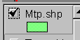 you which ones you will need. These are included
in the notebook.
you which ones you will need. These are included
in the notebook.
| Township | Range |
| 30S | 30-32W |
| 31S | 29-32W |
| 32S | 29-31W |
| 33S | 29-31W |
It is generally easiest to color the parcels first on paper and depending on how complicated the map is, cut them out and tape them together. We won't be using the digitizer to put the parcels in .. instead we will freehand them. As was mentioned in the previous sections, DNR's land status coverage is based on the section level. MTPs show actual surveys so a more accurate depiction is possible.
Obtain copies of MTPs, including supplemental plats if available.
Activate the township theme and drag it to the top of the list (display first).
Create a new shape file for the MTP data.
View; New Theme; Polygon and save in you home folder as
mtp.shp
and save in you home folder as
mtp.shp
Zoom into the mouth of the Karluk River.
There are private parcels located there that must be added to mtp.shp.
Activate and select mtp.shp and
Theme; Start Editing. The draw polygon
tool can be found in the drawing
button, which should be the last on the right on the bottom toolbar.
Clicking the arrow on the bottom right corner of the button will make the
button expand to a bar. Choose the pac-man-ish button . Now
you can begin to draw in the polygons, using left button clicks to add
points and doubleclicking when done. You can utilize the right button
zoom in/zoom out and pan buttons to move around while you are creating
polygons.
 Now
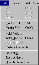
tabular data will be added for each polygon you create. Edit;
Add Field will allow you to add a column to the table - in this case
we will add a column for land ownership and one for the ADL number.
This information can be brought up later by simply clicking on the polygon
in the View.
Now
tabular data will be added for each polygon you create. Edit;
Add Field will allow you to add a column to the table - in this case
we will add a column for land ownership and one for the ADL number.
This information can be brought up later by simply clicking on the polygon
in the View.
Continue with Tutorial
Previous item in Tutorial
Return to ArcView Tutorial 2: List of Topics
Return to Main Menu